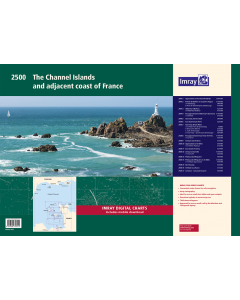
2500 The Channel Islands and adjacent coast of France Chart Pack
- FREE Delivery to UK - Spend over £75
- FREE Delivery to Europe - Spend over £150
- Worldwide Delivery Available
Imray Chart Pack
Product Details
Part Number: YOT0856
Scale: 1:1(Various)
ISBN: 9781846238611
Publisher: Imray Laurie Norie And Wilson Ltd
Author(s): Imray
Edition: 2022
Printed and corrected to: October 2022
Format: Folio - A2 Size
Language: English
MPN: IC2500-4
The pack consists of the following:
- 2500.1 Approaches to the Channel Islands (1:500,000)
- 2500.2 Cap Barfleur to Alderney (1:150,000), includes plans:
- A Cherbourg (1:40,000)
- B Port de Chantereyne (Cherbourg) (1:10,000)
- 2500.3 Alderney & Burhou (1:25,000) includes plan A Alderney Harbour (1:12,500)
- 2500.4 Passages between Alderney & Guernsey (1:150,000) includes plan A Diélette (1:15,000)
- 2500.5 Guernsey, Herm & Sark (1:60,000)
- 2500.6 East Guernsey & Herm (1:25,000)
- 2500.7 Guernsey & Sark Plans:
- A St Peter Port & Havelet Bay (1:6,000)
- B Beaucette Marina (1:10,000)
- C Sark Anchorages (1:25,000)
- D Guernsey - South Coast Anchorages (1:25,000)
- 2500.8 Passages between Guernsey & Jersey (1:150,000) includes plan A Carteret (1:25,000)
- 2500.9 Jersey & Les Écrehou (1:75,000)
- 2500.10 Approaches to St Helier (1:30,000) includes plan A St Helier Harbour (1:15,000)
- 2500.11 East Coast of Jersey (1:25,000)
- 2500.12 Jersey to Granville (1:150,000) includes plan A Granville (1:20,000)
- 2500.13 Plateau des Minquiers (1:50,000)
- 2500.14 Plateau des Minquiers to St-Malo (1:150,000) includes plan A St-Malo (1:55,000)
- 2500.15 Îlles Chausey (1:30,000)
- 2500.16 St-Malo & La Rance (1:15,000) includes continuation to Lyvet (1:25,000)
- 2500.17 La Rance - Cancaval to Lyvet (1:25,000)
Imray Digital Charts: Free mobile download
A voucher code to download the relevant Imray digital charts into the Imray Navigator app is included with this atlas.


![NP255 - ADMIRALTY Tidal Stream Atlas: Falmouth to Padstow [including Isles of Scilly]](https://www.bookharbour.com/media/catalog/product/cache/f073062f50e48eb0f0998593e568d857/n/p/np255_1.jpg)

![Channel Havens: Secret Inlets & Secluded Anchorages of the Channel [BACKORDER]](https://www.bookharbour.com/media/catalog/product/cache/f073062f50e48eb0f0998593e568d857/p/i/pil0580.jpg)
