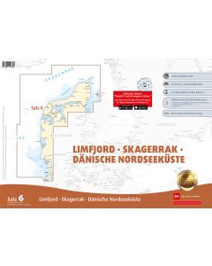
DE 10: NV Atlas Nordfriesland - Sylt bis Helgoland & Eider

- FREE Delivery to UK - Spend over £75
- FREE Delivery to Europe - Spend over £150
- Worldwide Delivery Available
This atlas contains a download code for all charts in this area to be used with the nv chart app. The app is compatible with Apple: iOS/MacOSX, Android & Windows: 7/8/10.
Product Details
Part Number: YOT0006DE10
Scale: 1:1(Various)
ISBN: 9783945902103
Publisher: NV Charts
Edition: 2024
Printed and corrected to: edition date
Format: Combipack - Paper / Download and app
Language: English, German
MPN: 9823
The North Frisian Islands off the west coast of Schleswig-Holstein are a popular holiday destination in the North Sea in the Schleswig-Holstein Wadden Sea National Park. Each island has its own charm and offers personal holiday happiness for every taste. Green dykes, long beaches and lots of sheep, these are the most famous characteristics of the five islands of Nordstrand, Pellworm, Föhr, Amrum and Sylt. With the chart set DE 10 you will not only find all the details for a safe journey for the North Frisian Islands, but also the Eider and Helgoland areas. The North Sea is demanding, but with good literature and up-to-date nautical charts you can lay the foundation for your trip through this area of the sea, whether by sailboat or motorboat. The chart series already contains the information on current and tide and both tides and currents are shown on the charts in an easily understandable way.
This chart set includes
- 3 oversailers
- 17 cruising charts
- 16 details
- Tidal calendar and tidal currents included
- Digital charts for navigation program and nv charts app 365 days licence
- Port plans paper & Digital
- Navigation instructions in German and English
Update - Update
The chart sets for the German North Sea are published annually in updated editions. Up-to-date nautical charts are the basis of safe navigation. NV Charts offers a
monthly update service from April to October for its German North Sea charts. So that you are always "up-to-date".
NV Atlas chart format
NV Charts nautical charts are available in an outstandingly practical, handy atlas booklet format and thus offer many advantages over formats from other manufacturers. The nautical chart series have been designed by nautical experts and passionate water sports enthusiasts with the needs of recreational boating in mind.
The NV Atlas has a very flat staple binding in the middle, so that the course triangle can also be used there without any problems. This innovative development makes it possible to look up charts quickly and always have them in the best possible order at the same scale. The NV Atlas is delivered in a plastic cover protected against splash water. This modern nautical chart format is very popular on sailing boats as well as on motor yachts and is the preferred choice of many of our customers.
NV Charts navigation app
All NV Charts nautical charts also include an access code to the digital nautical charts in the NV Charts app and can thus be easily downloaded and used for offline navigation with the NV Charts app on iOS, Android, PC and Mac or also in the web browser.
The NV Charts app is the ideal addition on mobile devices. With the app, you can already plan a detailed route at home and thus prepare for your journey in the best possible way in conjunction with the paper chart. The app is intuitive to use and, thanks to an identical map image, you can orientate yourself on paper and digitally in a matter of seconds. The most up-to-date information is essential to navigate safely on the water with your sailboat or motorboat.
With the NV Charts app, you now have the opportunity to become part of the chart community. You can mark harbours, anchorages and navigation warnings on the digital nautical chart and also add interesting places beyond navigation, such as restaurants, with pictures and comments and share your experiences with other users. In addition, the NV Charts app offers an automatic routing function, search and all navigation functions for GPS navigation with your phone or tablet. More information at: nvcharts.com/app
More PC navigation apps: NV Verlag / NV Charts nautical charts can also be used in many other nv.digital compatible PC navigation programs such as NV Chart Navigator or Open CPN.
Containing charts and scales
Oversailers
C1 North Frisia 1: 375.000 C2 Rømø to Süderoogsand 1: 150.000 C3 Helgoland to Süderoogsand 1: 150.000
Revierkarten
C4 Lister Tief Nord 1: 50.000 C5 Lister Tief Süd 1: 50.000 C6 Vortrapptief 1: 50.000 C7 Hörnumtief 1: 50.000 C8 Rütergat 1: 50.000 C9 Norderaue - Süderaue 1: 50.000 C10 Norderhever Nord 1: 50.000 C11 Norderhever and Heverstrom 1: 50.000 C12 Rütergat to Mittelhever 1: 50.000 C13 Norderhever Süd 1: 50.000 C14 Süderhever and Heverstrom 1: 50.000 C15 Norderpiep to Eidersperrwerk 1: 50.000 C16 Norder- & Süderpiep 1: 50.000 C17 Meldorfer Bucht 1: 50.000 C18 Tideeider 1: 25.000 C19 Die Eider - Wollersum to Nordfeld 1: 25.000 C20 Die Eider - Nordfeld bis Lexfähre 1: 50.000 C21 Ansteuerung von Helgoland 1: 50.000
Detailkarten
C10A Port of Büsum 1: 12.500 C10B Port of Dagebüll 1: 25.000 C10C Schlüttsiel 1: 12500 C17A Meldorfer Hafen 1: 12500 C18A Eidersperrwerk 1: 10000 C18B Tönning 1: 10000 C19A Friedrichstadt 1: 10000 C20A Husum 1: 12500 C20B Gieselau Schleuse 1: 14.000 C22 Helgoland 1: 12500 C24A Port of Amrum 1: 25000 C24B Port of Pellworm 1: 12500 C24C Hörnum 1: 7500 C24D Port of Rømø 1: 9000 C24E List 1: 5000 C24F Wyk 1: 7.500 Sign Explanation - Legend C23 General Notes - General Notes C23 Tide Calendar - Tide Tables C24-25