North Brittany Pack

- FREE Delivery to UK - Spend over £75
- FREE Delivery to Europe - Spend over £150
- Worldwide Delivery Available
Pack includes Imray pilot book & folio of charts for North Brittany
Product Details
Part Number: PIL0409;YOT0861
Edition: No
Printed and corrected to: No
Publisher: Imray Laurie Norie And Wilson Ltd
Language: English
Format: No
Channel Islands, Cherbourg Peninsula and North Brittany
This revision of the RCC Pilotage Foundation's pilot updates the combined volume for this area which encompasses the Channel Islands and extends from St Vaast La Hougue on the east of the Cherbourg peninsula, and works westwards along the Normandy and Brittany coasts to Ouessant. Coverage includes the Plateau des Roches Douvres as well as detailed sections on the navigable rivers.
The navigator benefits enormously from the painstaking approach with which Peter Carnegie has documented his own explorations of these, his home waters. His numerous annotated photographs and the many accompanying charts detail the network of transits between the off-lying rocks and islands of the region. Waypoints are used judiciously to further inform, but the emphasis remains on time-proven and trusted methods of safe navigation in these waters of high tidal range and fast-moving currents.
The Channel Islands, Normandy and Brittany coasts can seem a daunting sailing area for those unaccustomed to their ways, but ‘Carnegie’s book provides reassurance and so much practical advice that anyone using it will feel confident of success.' (Yachting Monthly). It is the definitive pilot for anyone interested in the challenge of exploring the less frequently used passages and anchorages.
2510 North Brittany Chart Pack
2510.1 The Channel Islands, Cherbourg Peninsula & North Brittany
1: 550 000 WGS 84
2510.2 Approaches to St-Malo & St-Cast-le-Guildo
1: 120 000 WGS 84
2510.3 Cap Fréhel to Paimpol
1: 110 000 WGS 84
Plans Rade de Portrieux (1:50 000), Chenal d’Erquy (1:50 000)
2510.4 Roches Douvres to Rivière de Tréguier & St-Quay-Portrieux
1: 110 000 WGS 84
2510.5 Approaches to Rivière de Trieux & Paimpol
1: 50 000 WGS 84
2510.6 Plans – St-Malo to Lézardrieux
1: various WGS 84
Plans St-Malo Approaches (1:55 000), St-Malo (1:17 500), Saint-Cast-Le-Guildo (1:20 000), Erquy (1:20 000), Dahouët (1:10 000), Port du Légué (1:20 000), Binic (1:12 500), St-Quay-Portrieux (1:25 000), Paimpol (1:15 000), Port de la Corderie (Île de Bréhat) (1:15 000), Port Clos (Île de Bréhat) (1:10 000), Lézardrieux (1:15 000)
2510.7 Approaches to Rivière de Tréguier
1: 35 000 WGS 84
Plans Tréguier (1:15 000)
2510.8 Les Héux de Bréhat to Primel
1: 110 000 WGS 84
2510.9 Baie de Morlaix
1: 50 000 WGS 84
Plans Primel (1:15 000), Port de Morlaix (1:15 000)
2510.10 Plans – Tréguier to Île de Batz
1: various WGS 84
Plans Port-Blanc (1:25 000), Anse de Perros (1:30 000), Ploumanac’h (1:10 000), Approaches to Trébeurden (1:35 000), Le Léguer (1:42 500), Canal de l’Île de Batz to Roscoff (1:20 000)
2510.11 Île de Batz to Île Vierge
1: 75 000 WGS 84
Plans Moguériec (1:32 000), Port du Pontusval (1:25 000)
2510.12 L’Aber Wrac’h to Argenton
1: 40 000 WGS 84
Plans Argenton (1:25 000)
2510.13 Île Vierge to Rade de Brest
1: 100 000 WGS 84
Plans L’Aber-Ildut (1:25 000), Port du Conquet (1:20 000)
2510.14 Le Four to St Mathieu & Île d’Oussant
1: 80 000 WGS 84
Plans Baie de Lampaul (Ouessant) (1:30 000), Baie du Stiff (Ouessant) (1:30 000)
On this edition the latest depth surveys have been applied. A tidal stream page has been added along with updated tidal data and contact details of harbours, marinas and coastguard stations. There has been general updating throughout.
Imray Digital Charts: Free mobile download
A voucher code to download the relevant Imray digital charts into Imray Navigator (our app for iPad, iPhone and Android) is included with this pack.
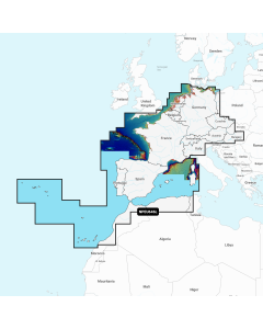
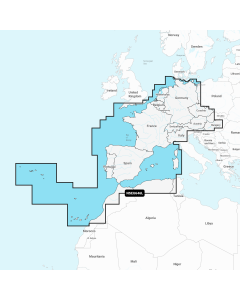
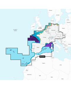
Atlantic Europe Large Digital Charts
-
Navionics+ Large - Europe, Central & West
Special Price £220.00 Regular Price £229.99Stock In stock -
-
-